Yosemite NP:
• Yosemite NP
• Mariposa grove winter
trails map
Avalanche forecast:
• Avalanche Center
• Avalanche.org
• Sierra Avalanche Center


Mariposa Grove Loop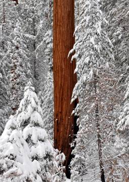
Facts:
Distance: 10.1 miles
Altitude at starting point: 5080 ft.
Altitude at destination point: 5080 ft.
Elevation gain: 1720 ft.
Total descent: 1720 ft.
Duration: 6 h.
Date: 02/13/2010
Gear: Alpine touring
This route starts at the park’s South entrance and follows the Mariposa grove road to the lower and upper groves of giant sequoias and on to the Wawona Point Vista. A mix of road and trails are used to cover the entire Mariposa grove. It’s recommended to ski the upper grove counter clockwise since it’s less steep on the South and East legs.
Two types of signs are found on this route: yellow reflective triangles nailed on trees and yellow reflective squares sticking out of tree trunks. The trails are pretty well marked and you shouldn’t have any problems finding your way under good weather conditions.
Skiing through these giant sequoias is a magical experience. Their distinctive reddish bark color stands out from the snow blanket on the background. It would seem their size is not enough for these giants to declare themselves kings of the forest.
Description of the route:
Park your car at the designated area next to the park’s South entrance. Waypoint MG01 Parking: N37° 30.450 W119° 37.899. The first stretch of the road may not be covered by snow and some walking may be required. Put your skins on and follow the road to the first picnic area at 1.3 miles. Waypoint MG02 WC2: N3° 30.089 W119° 37.284. Keep on the road until passed the Gift shop at 2 miles. Waypoint MG03 GiftShop: N37° 30.064 W119° 36.666.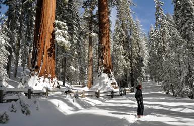 Leave
the road to the left and enter the lower grove. Here you can see the first giant
sequoias. Follow the fence next to the map board, cross the stream over the bridge
and rejoin the road. Meet the Bachelor and the 3 Graces group at 2.4 miles (see
picture). Waypoint MG04 Bachelor3Graces: N37° 30.236 W119° 36.290.
After passing this group, leave the road and take the trail to the left following
the creek. Cross a couple of bridges (Waypoint MG05 Bridge1:
N37° 30.239 W119° 36.209 and MG06 Bridge2: N37° 30.228 W119°
36.168).
Leave
the road to the left and enter the lower grove. Here you can see the first giant
sequoias. Follow the fence next to the map board, cross the stream over the bridge
and rejoin the road. Meet the Bachelor and the 3 Graces group at 2.4 miles (see
picture). Waypoint MG04 Bachelor3Graces: N37° 30.236 W119° 36.290.
After passing this group, leave the road and take the trail to the left following
the creek. Cross a couple of bridges (Waypoint MG05 Bridge1:
N37° 30.239 W119° 36.209 and MG06 Bridge2: N37° 30.228 W119°
36.168).
The next giant sequoia in this route is the Grizzly tree at 2.7 miles. Waypoint MG07 Grizzly: N37° 30.204 W119° 36.078. Go around to the left and you’ll find the California tree at 2.7. Waypoint MG09 CaliforniaTree: N37° 30.248 W119° 36.020. Follow the signs until the junction at 3 miles. Waypoint MG11 Junction2: N37° 30.358 W119° 36.234. Turn left for returning to the car. Keep straight to head to the upper grove. Again keep straight at the next junction at Waypoint MG12 Junction3: N37° 30.353 W119° 36.252. Follow the wide trail until mile 3.5. Waypoint MG14 Junction5: N37° 30.458 W119° 36.563. Here you have the possibility to turn left and go towards Wawona but this route turns right to the upper grove following the MG-4 trail.
The next giant sequoias are at 3.9 miles where the MG-4 trail connects to the road. Waypoint MG15 Rd&FaithfulCouple: N37° 30.589 W119° 36.251. Follow the road up until Waypoint MG16 Junction6: N37° 30.627 W119° 36.180 and at the sharp curve to the left, leave the road to the right. The next point where you’ll hit the road is at 4.4 miles. Waypoint MG17 Junction7: N37° 30.766 W119° 36.077. Take the upper loop road to the right and follow it passing the Telescope tree. At 5.2 miles you’ll arrive to the highest point of the road. Waypoint MG20 Junction9: N37° 30.969 W119° 35.697. From here turn right to climb to the Wawona viewpoint at 5.8 miles. Waypoint MG21 WawonaPoint: N37° 31.117 W119° 36.044.
Take your skins off and get ready for the downhill to the parking area. On your way down, visit the Mariposa tree at 6.9 miles. Waypoint MG23 MariposaTree: N37° 30.857 W119° 36.291. Leave the road at 7.3 miles to the right. Waypoint MG24 LeaveRoad: N37° 30.654 W119° 36.300. Take a left at 7.7 miles. Waypoint MG14 Junction5: N37° 30.458 W119° 36.563. Turn right at the next junction and take the MG-1 trail down to the road at the entrance of the lower grove at 8.1 miles. Waypoint MG25 WC3: N37° 30.106 W119° 36.687. From here follow the road down to the parking area. Arrive at the gate at 10.1 miles.
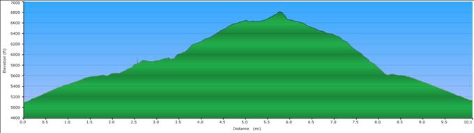
Profile of the Mariposa grove route.