Avalanche forecast:
• Avalanche Center
• Avalanche.org
• Sierra Avalanche Center


 Crafts and Butler Peaks
Facts:
Distance: 9.2 miles (out and back)
Altitude at starting point: 6965 ft.
Altitude at Crafts Peak: 8361 ft.
Altitude at Butler Peak: 8544 ft.
Elevation gain: 2770 ft.
Total descent: 2770 ft.
Duration: Not representative
Date: 03/13/2010
Gear: Alpine touring
This activity is located in the San Bernardino National Forest, very close to Big Bear Lake. Yes, in a good year, you can backcountry ski in Southern California. This route should be attempted after recent heavy snow fall.
The route starts at the Green Valley Campground and climbs the Rim of the World ridge to summit first the Crafts Peak and then the Butler Peak. It is not signed but it follows mainly roads or ridges so it’s easy to navigate. You can turn around at the Crafts Peak but the view from the lookout tower at the Butler Peak is worth the extra effort. From there, you have a 360 degrees view including the Big Bear Lake, Mt. Baldy (aka Mt. San Antonio) and Mt. San Gorgonio. On a clear day, you can also see Mt. San Jacinto beyond the San Gorgonio.
Description of the route:
Park your car at the Green Valley Campground gate, at the end of the Green Valley Lake Rd. (Waypoint BP 01 TrailHead: N34° 14.664 W117° 03.863).
Depending on the snow conditions and your gear, you may not need skins for the first section of the trail. At 375 feet from the gate there are restrooms but they are closed in winter (Waypoint BP02 WC: N34° 14.707 W117° 03.845). Turn right and follow the road up till a second gate at mile 0.6 (Waypoint BP03 EndRoad: N34° 14.904 W117° 03.470). Two hundred feet passed the gate, go right at the fork between roads 2N13 and 2N19A (2N13A on Google maps) (BP04 GoRightFork: N34° 14.887 W117° 03.438).
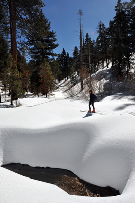
At mile 1.2 keep on the same road bearing left and crossing the stream (see top picture) (Waypoint BP05 JuncXStream: N34° 14.539 W117° 03.056). Follow the road up until a sharp curve left where you leave the road to the right (mile 1.7) (Waypoint BP06 LeaveRoad: N34° 14.480 W117° 02.581) and start climbing up to the ridge. When you get to the ridge follow it in NE direction.
 After
a short downhill, cross a creek at mile 2.3 (Waypoint BP07 XStream01:
N34° 14.736 W117° 02.191). Go up again and at mile 2.4, you’ll get to a
blue diamond mark on a tree (Waypoint BP08 Bluediamond: N34° 14.751
W117° 02.103). You are now on the road you’ll be using for the descent. Follow
the ridge with a couple more ups and downs and at mile 3 reach the Crafts Peak
(Waypoint
BP09 CraftsPeak: N34° 15.076 W117° 01.774). Butler Peak is 1.5 miles
from here (one way). If you decide to continue, follow the ridge, negotiating
around the rocky outcrops and watching for cornices (see picture on the
left).
After
a short downhill, cross a creek at mile 2.3 (Waypoint BP07 XStream01:
N34° 14.736 W117° 02.191). Go up again and at mile 2.4, you’ll get to a
blue diamond mark on a tree (Waypoint BP08 Bluediamond: N34° 14.751
W117° 02.103). You are now on the road you’ll be using for the descent. Follow
the ridge with a couple more ups and downs and at mile 3 reach the Crafts Peak
(Waypoint
BP09 CraftsPeak: N34° 15.076 W117° 01.774). Butler Peak is 1.5 miles
from here (one way). If you decide to continue, follow the ridge, negotiating
around the rocky outcrops and watching for cornices (see picture on the
left).
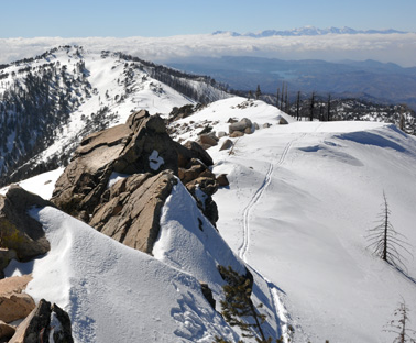 The last few yards to the lookout tower are on a steep slope. Walk up the
stairs to the tower to enjoy the view (Waypoint BP10 ButlerPeak:
N34° 15.392 W117° 00.472). Looking back towards Crafts Peak, you may
be able to see Mt. Badly in the distance (see picture on the right).
The last few yards to the lookout tower are on a steep slope. Walk up the
stairs to the tower to enjoy the view (Waypoint BP10 ButlerPeak:
N34° 15.392 W117° 00.472). Looking back towards Crafts Peak, you may
be able to see Mt. Badly in the distance (see picture on the right).
Remove your skins and ski down till mile 5.4 (Waypoint BP11 Skinson: N34° 15.317 W117° 01.359) where you’ll have to put your skins on to climb up Crafts peak and a couple of small uphills farther on. Actually, you don’t have to get to the peak; you can flank it on its north side. Follow your tracks up to the highest point of the return at mile 6.4 (Waypoint BP12 Skinsoff: N34° 14.786 W117° 02.007).
Remove your skins and ski down the road. At mile 6.6 there is a sign on the right hand side of the road (Waypoint BP13 Road: N34° 14.737 W117° 02.101). From here, it's all the way down to the parking lot, except for a couple of very gentle uphills where you won’t need skins. Cross the stream again at mile 8.1 and go right (Waypoint BP14 XStream02: N34° 14.543 W117° 03.019). Arrive at your car at mile 9.2 (Waypoint BP15 TrailEnd: N34° 14.668 W117° 03.859).
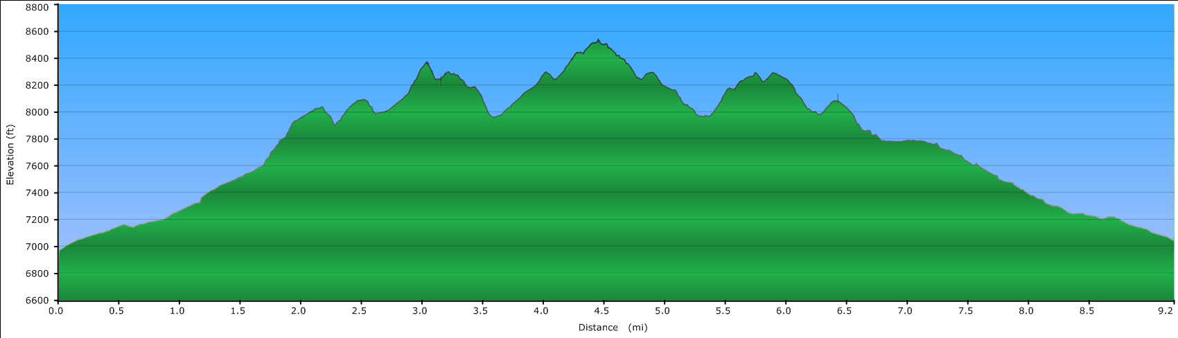
Profile for the Crafts and Butler Peaks route.