• Logbook
• Road Stars
Photo album:
• Torres del Paine NP
Download Torres del Paine NP files:
• Ride GPS track & waypoints
• Hike GPS track & waypoints
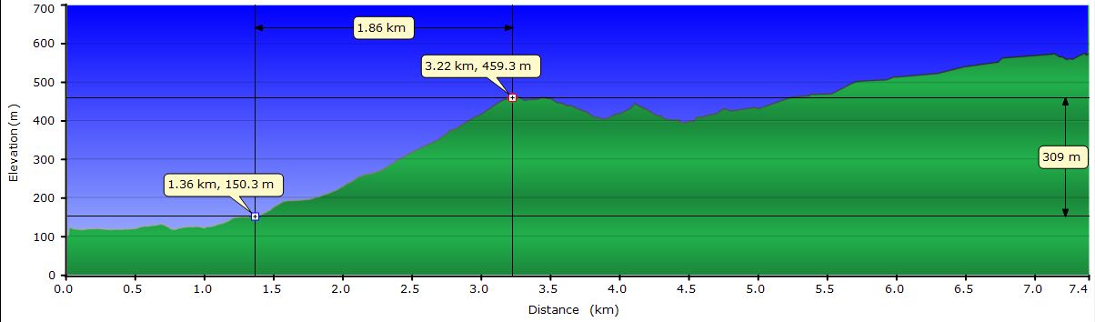
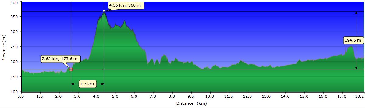
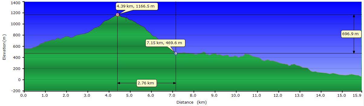
• Profile day 1
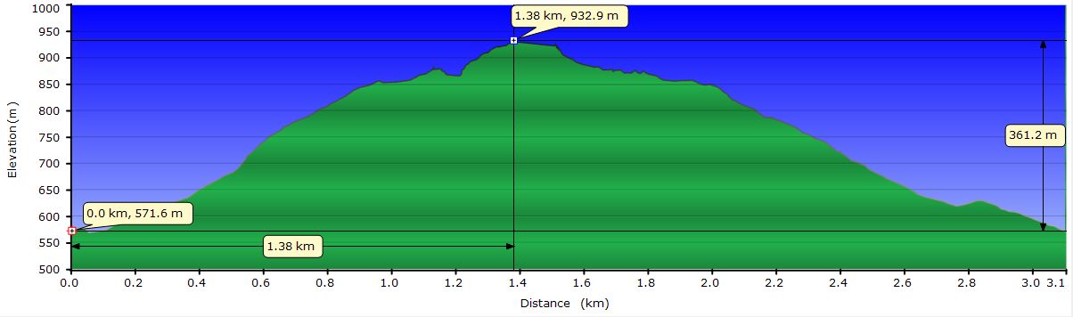
• Profile Torres VP
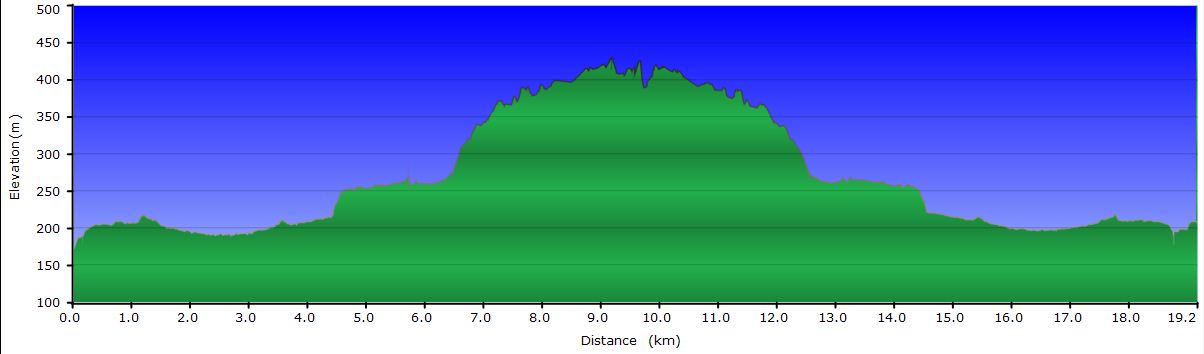
• Profile day 2
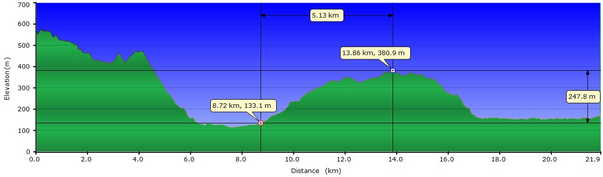
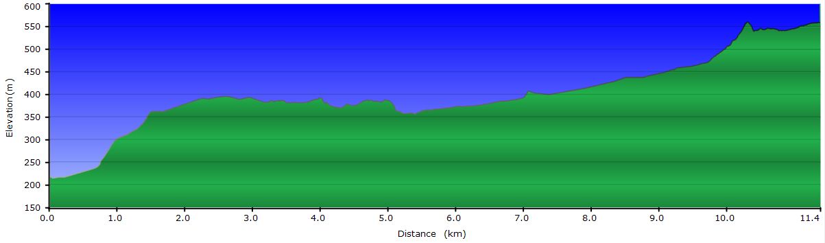
• Profile day 3
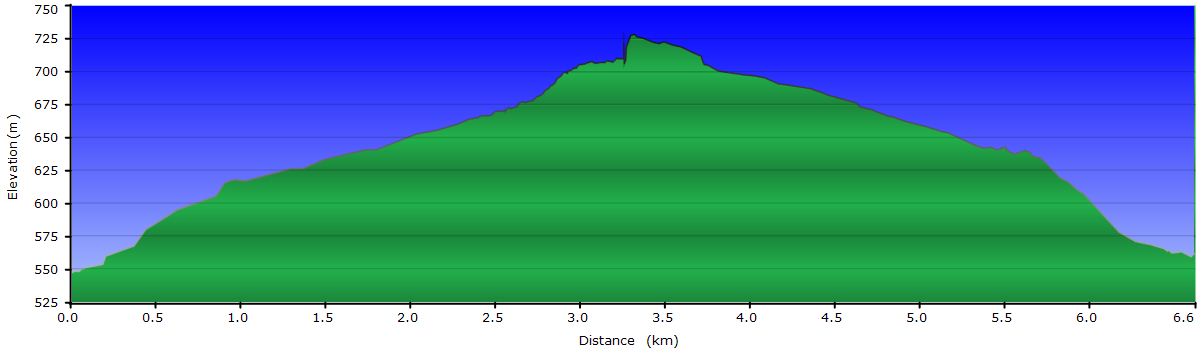
• Profile Dickson G.
• Profile day 4
• Profile Puma G.
• Profile day 5
• Profile day 6
• Profile Cuernos VP
• Profile day 7
• Profile day 8


.JPG)
February 13th, 2011: from Puerto Natales to río Serrano
 We pack the food for the next 15 days. The road up to the Park will take us 3 days. Our plans are to hike around the Paine Massif in an excursion known as "The big circuit" and complete it with a couple of side trips, el Valle del Francés and the base of las Torres del Paine. These extensions are known as the "W". This should take about 8 days. After this visit to the Park, we will go to El Calafate. Instead of going along the road that crosses to Argentina and runs 300 km through the pampa, we would like to cross through the Baqueano Zamora pass, also known as la Rosada pass. This crossing is not usually allowed, but we have asked permission to the authorities for its temporary habilitation for us. If they grant us with the permit, we will have to ride about 50 km only. However, it seems that the terrain can be complicated for pedaling (we don´t even know for sure if there is a road) and the information we have been able to find talks about km and km of cross country bike pushing. We estimate that this crossing would take us 3-4 days. Even with all the unknowns we prefer this alternative to the windy desolation of the pampa.
Today, during the first kilometers, we are fortunate to see all kinds of birds. We see black-necked swans swimming on the Última Esperanza (Last Hope) inlet. A little bit later, condors and other birds of prey feeding on a dead horse. After that, a pair of eagles and multitude of caranchos take advantage of the consequences of the slowness of the hares crossing the road.


Our first stop of the day is at the cave of the Milodón, a tourist attraction of little visual interest but great historical interest for the study of the inhabitants of the area dating back to 10,000 years b.c. Here, a local farmer found a skin of the extinct giant sloth that inhabited the area during this period. Since 1900, when the archaeological remains of the cave were discovered, the locals carried out several raids to sell the remains found to museums. All this looting makes it difficult to study and reconstruct the history of the cave. There is much controversy on the subject; it seems to be generally accepted that the giant sloth and the paleo-indians lived in this area at the same time, but discarded it was domesticated as some theories suggest.


So far the weather holds, but the distant peaks on the background, are covered by a mist that looks more rain than clouds. Indeed, arriving at the first of the glacial lakes that the road links, it begins to drizzle. The wind also intensifies, but the worst part is the 2 hills we have to climb. They are not high at all but due to the weight of all the food we carry, they become endless at the end of the day. We cross the bridge over the Serrano River and turn left towards the Serrano campground. We find out there are showers with hot water and each campsite has a shed with light where we can shelter from the rain and wind. It has started to rain again and it seems that this time is not going to stop anytime soon. The long day has definitely been worth.
If this was not good enough, our neighbors are a lovely Chilean family. When we are preparing our soup, Gabriel and Berni, two of the kids, show up to invite us to have dinner with them. The portions of risotto they are preparing are much bigger than expected and they have plenty. We immediately accept the offer and move to their shed. There we meet with Pedro and Cecilia, the parents, and Caro and María La Paz, the two other girls. We keep talking and laughing until almost noon when the electricity generator of camping is turned off.
February 14th, 2011: río Serrano

It has been raining all night long and when we wake up it still does. We have only a small area wet in our tent, but our neighbors have not been so lucky: their sleeping bags are soaked. Today they had plans to go to the Las Torres lookout, but the sky is completely covered so they leave for Punta Arenas. As they go back one day before planned, they give us their extra food that we gladly accept. After we say good bye, we go to our shed and prepare scrambled eggs, cereals with milk and a salad of tomato and avocado. Many thanks to our friends!


As the morning goes by, the sky clears up and the sun begins to shine. The Paine massif can now be seen from the campsite, but the peaks remain covered. It’s already noon and we decide to stay instead of pedaling to the hotel Las Torres, starting point for the hike. We go fishing. My tiny fishing pole is not the right weapon for the monsters that inhabit the Serrano river. I lose 3 lures because the trout and salmons are too big for my line and they snap it right away. At this point I’m experienced enough to distinguish between a rock and a fish. I have also seen what seemed to be a 2-foot salmon showing its back out of the water. And it is not a fisherman’s exaggeration. A couple of true fishermen have caught a 36 and 30 Lb. salmons nearby. It comes to my mind that at the campground office they have fishing gear for rent. Here I am, back with the appropriate gear. Unfortunately, the result is the same; I lose three more lures, one on the rocks, but the other 2 due to beast salmons. Back to the campsite, they lecture me on how to deal with the Serrano beasts. Too late, salmons: 6, Cèsar: 0. Today we will not have fish for dinner.
 At least the views of Los Cuernos del Paine (Horns of the Paine) from where we've been fishing are spectacular. Although a bit far, the prairie that separates us from them, gives a more complete landscape.
Dinner frustration is not a big deal due to the food that Pedro, Cecilia and their family left us.
February 15th, 2011: from río Serrano to hotel Las Torres
 The road leads us straight to the Paine massif. Part of the way runs upstream along the Paine River. Its blue-greenish waters clearly reveal that it comes from the massif glaciers. The Paine has a considerable width for the short-haul at this point. At some places, it has more than 50 meters from shore to shore. But all that water is concentrated in about 5 meters at the Salto Chico waterfall. As its name suggests, its height is perhaps as low as about 30 feet, but the flow is spectacular. The pulverized water on the rocks creates a rainbow giving the scene a magic touch, despite the pipes the Explora hotel has installed for their water supply.
We are entering the zone of lakes connected directly to the southern Patagonian ice field. The first is the Lake Pehoé. For cyclists, this means wind gusts that blow you out of your bike as we experienced a few years ago in this same area. Back then Judit, as usual, was smarter and stopped the bike and laid down on the ground when we saw the wave of dust and pebbles coming. It blew me away and besides a few scratches, it broke a couple of spokes. The wind traveling from the Pacific passes between the peaks of the range and glaciers are least resistance way to cross it. Many glaciers discharge their ice in these lakes and are a natural funnel for the wind. Today we are luckier than last time and there are no major incidents besides a gust the makes Judit to lose control of the handlebar and stop. At least this year, it comes from our backs. When climbing, this is great; when the gusts come, we shift to a smaller sprocket to accelerate and take advantage of the push.
")

The second of the big lakes is the Lake Sarmiento. This one has the peculiarity of having tributaries that feed it, but no drainage. As a result, water is only lost by evaporation and with water so loaded with minerals, it creates a unique ecosystem with a water pH of 9. Its shores are white due to a kind of coral that is formed by several species of bacteria as a by-product of their photosynthesis. On the other side of the dirt road is the Lake Nordenskiöld, which pours its waters to the Pehoé in el Salto Grande waterfall. Along the route we can see many guanacos. They are so used to vehicles passing by that they don´t even blink and provide us with opportunities to observe them really close.
 Los Cuernos are also very close and are just as impressive as the first time we saw then. Those black sharp tips make them even more aggressive. Watching from below they seem unassailable.
Finally we arrive to the hotel Las Torres. Our initial plan was to leave here the bikes and the panniers, take our backpacks and hike to Las Torres campground, from where we want to climb to the Las Torres lookout to see the sunrise. It’s too late, so we decide to leave tomorrow and we camp for the night.
February 16th, 2011: from hotel Las Torres to Las Torres camp
We wake up on a clear day and from our tent we can see Las Torres almost complete except for their peaks that are wrapped in clouds. We prepare the backpacks, leave the bikes at the hotel and start hiking towards Las Torres camp. This is by far the most popular hike in the park and that means way too many people.
 The climb along the Ascensio river becomes familiar as we progress. It constantly reminds me of the adventures and misadventures that took place the first came I came here with our good friend Pablo. To read about them, you'll have to read his wonderful narration. (only in Spanish).
After a quite steep initial climb, the trail levels out some. In this stretch, the path flanks a scree and we can enjoy the views. Below the turbulent river, the snow-capped mountains on the background and across the valley some odd rock formations that have been uncovered by the erosion. After the refuge Chileno, the trail runs through wooded area. From time to time, we cross a forest clearing and we can check that the towers still remain there and most importantly, they are already totally visible.
After setting up the tent at Las Torres camp, we go up to the lookout to enjoy the views. The trail climbs steep hiding them, so you do not know if they are visible until you get over the ancient glacier's moraine. Yes! They are still there, mostly clear of clouds. Only a few shredded clouds block the tips. Their walls are so vertical the snow doesn’t hold. Even when they are in the shade, the panorama is daunting. The granite wall is impassable. The lagoon at their feet is the single access point. We seek shelter behind a large boulder and we stare at them while we eat. We return to our tent half frozen hoping for a clear sunrise so we can see the sun line going down their walls.
February 17th, 2011: from Las Torres camp to Serón camp
Fifteen minutes before the alarm triggers, the hustle and bustle in the camp wake us up. It’s 5: 30 AM but outside there are already some lights moving towards the lookout. We put on almost all the clothes we carry and come out of our tent to the outside world, where it is still dark. We join the string of luminous dots climbing the slope that leads to the viewpoint. When we get there, we look for the granite boulder we used yesterday to protect ourselves from the wind. The flat rocks we placed serve us as seating and table to prepare breakfast. The hot milk and oats are awesome to fight the cold while we wait for the first rays of sun to illuminate Las Torres. The sky is clear, so the show is guaranteed.
 Like in a concert opening, all spectators cheer of joy. The tips of Las Torres are fuzzy behind low-density clouds so the early pinkish tones appear a little further down.The orange tones follow, then the yellowish ones and finally, when the sun illuminates them fully, the real colors appear. The shadow line is very well defined on the vertical walls of Las Torres. You can see how quickly at the beginning and more slowly afterwards, the line descends until it reaches the lagoon where it disappears. The three main towers are monoliths of granite, but the wall to the right has two different types of rock. The next wall is composed of dark rock. To the left of the towers, are the classical strata of Los Cuernos. Altogether, the glacial cirque has an incredible beauty. We stayed there for a long time wondering why it is such a magnificent view.
 The camp is a frenzy mixture of ecstasy for the natural show that we have just seen and the urgency to start the descent down the valley. Some of us connect the descent with the first day of the big circuit. When we reach the hotel we have lunch, pick up the food for the 8 days of the circuit, load the backpacks and leave.
The scenery of this first day is not too dramatic. It runs mainly through prairies, crossing some lenga forests and dodging the Paine river tributary streams. Along the way we find thickets of ripe and much sweeter calafate berries than the ones we tasted in Puerto Navarino a month ago. An error on the distance on the park map to the Serón camp, makes it a long day. In addition, the camp itself has no charm. The best thing is the hot water shower and the caranchos nest located 60 feet up the hill. Little by little, the camp starts to fill up with the faces that will become familiar over the next few days. The afternoon is sunny and the wind has died out, which allows us to enjoy a few hours in the sun reading and writing this journal.
Oh, by the way, at the hotel we downloaded the e-mail and found out they have refused us the permission to cross through the paso Zamora, citing an unjustified economic cost. It seems that they want to physically move someone to the border point to make sure we're leaving Chile and entering Argentina. Our response contains a counter proposal to let us cross on our own and show up in El Calafate Gendarmes headquarters as soon as we get there. We don’t think it’s going to happen, so we are already thinking about alternatives to get to El Calafate. It seems that once again, the paso Zamora resists to be conquered.

February 18th, 2011: from Serón camp to Dickson refuge
Today is a long one but has few climbs, except for an initial slope that warms us up. At the end of it we reach the paso de Los Vientos (pass of the winds). Guess why! From there we have a wonderful view of the valley where the Paine River meanders and spills into the Lake Paine. After a long flanking we cross some plains between forest patches and a small pit bog without complications.
From the top of the last slope, we get the best view of the day, the glacier Dickson at the end of its lake. Below us we can see the Dickson camp, which we welcome. When we go down the steep downhill to the camp prairie, the sun finally decides to shine with strength and all colors stand out. The brilliant blue of the distant ice cracks on the glacier, the tips of Las Torres behind us hidden by a range of dark rock, the ochre of the grass in the meadow where we will camp and the brightly colored flags of Chile and the region of Magallanes flapping next to the refugio…
 We are tired and to recover, at least psychologically, we buy some chips and a 2 expensive beers but worth it. The afternoon is again very pleasant and for several hours we do nothing. When the wind picks up we hide inside the tent until dinner time. For half an hour it calms down and we take advantage of the last rays of sun to eat the soup at the table of our campsite. When the sun finally sets behind the mountains the mosquitoes show up and we go to bed.
Until now, these first two days of the circuit are not that spectacular as we expected. Perhaps our expectations were too high and we want to be continually surprised with exceptional views.
February 19th, 2011: visit to the Dickson glacier
 We are still lucky with the weather. The sun shines very bright from the first moment in the morning. The guys from the refugio yesterday convinced us that the visit to the Dickson glacier is an excellent side trip. They say the views of the front of the glacier are better than the ones at the Grey glacier. We still have a couple of days to get to the Grey glacier and there is no guarantee that the weather will stay sunny, so we decide to stay and tomorrow will continue with the big circuit. We join Pablo and Pili, a couple from Spain we already saw at campamento Serón. At the last moment, also Bruno and Valeria, a couple from Santiago de Chile, join us for the hike.
The route starts crossing the Paine River in an unconventional way. The river is about 75 feet wide and the current is strong at this time of the year due to ice melting. The guys from the refugio have installed a rubber boat as a ferry that works powered by human muscle. The boat is tied by a rope with a carabiner at the tip to a second fixed rope going from shore to shore. The carabiner slides on the fixed rope and you can imagine the rest. The crossing out is easier because the fixed rope is not perpendicular to the current, but at an angle which favors the crossing. In any case, crossing back is not complicated either.
 The trail runs through grassland and lenga forest, like the past two days, so it doesn't have a special interest. Each hill we climb, we check the glacier is getting closer. After about 6 mi we reach the Carabineros post that marks the end of the trail. The lookout is 5 minutes ahead. They inform us that we cannot continue beyond the lookout. It’s not allowed; Argentina is right there. In fact, the glacier itself is in Argentina. Clearly, the post’s goal is to show Chilean presence in the area.
When we reach the viewpoint, we become aware of what we have been suspecting all along. The front of the glacier is about 1 mi away. The view is good, you can see the magnitude of the cirque, all the snow slowly transforming into ice over the years and the wall of peaks enclosing it. You can also appreciate the different shades of blue due to the different concentration of air trapped in the ice. On the lake there are icebergs from the glacier. However, the front is too far away to enjoy it fully. Anyway, the 6 of us spend a couple of hours at the lookout distracted by a condor passing just ahead of us raising at full speed without moving a feather, chatting about anything and becoming silent when we hear the glacier rumble.

We are the first ones to leave the lookout because we want to ask the Carabineros about the paso Zamora. When we are getting close to their post, we see that they were coming for us. They tell us they were getting worried about us. We have the suspicion that they also wanted to verify we have not attempted to go beyond the viewpoint. As a result of the meeting, we start a conversation that ends up in an invitation into their small shelter where they offer us juice, bread and jam. Once again, we must stress their excellent hospitality.
When we get to our camp, the sun is almost behind one of the peaks that surround us. Hiker faces are different; the ones that came with us are already gone and new groups have arrived. Mosquitoes are the same as yesterday, though. A little fatter and very grateful to Judit for her blood donations…
February 20th, 2011: from Dickson refuge to Los Perros camp
The sun keeps shining. The guys at the refugio can’t believe it. So many consecutives sunny days is something unheard of in Las Torres del Paine. We say good bye and we start moving towards the trail that will lead us to campamento Los Perros. Before getting into the lush forest that will keep us in the shade almost all the way today, we fill our eyes with the view of the back side of Las Torres, a view reserved for the hikers of the big circuit.
The shade and moisture keep us protected from the heat of the day. This is the densest forest we have walked through so far. The vegetation is so dense that we can hear the rushed streams flowing down, but they remain invisible at the bottom of the valley. Only at the bridges across the Los Perros river we can appreciate the flow and strength of the water.
 Close to the camp, the forest opens up a little and the trail steepens up surprisingly. It seems that you could find another flatter route. We soon discover that we are climbing the moraine of Los Perros glacier. When we reach the crest, the view takes us by surprise. The glacier is small but very different compared to the Dickson. It is trapped between two rocky walls on a steep slope. At one point the gap between the walls is so narrow that ice has no other choice than to grow in thickness to overcome the rocky funnel and keep its way to the lagoon. It seems more a waterfall frozen in a moment than a glacier flowing down.
The route has been short today, but we want to rest for tomorrow, the dreaded John Gardner pass. When we arrive at the camp some hikers are still leaving for their pass attack. The shower is cold, very cold. On top of it, mosquitoes have followed us, according to the guy who is in charge of the camp. Usually there are no mosquitoes at Los Perros, only horseflies – he says. We quickly set up the tent and get inside, away from the insects. The idea of locking ourselves for the rest of the day doesn’t look very appealing, especially when the sun is shining outside. While we discuss the possibilities, Pili and Pablo arrive. After eating something, we propose them to go to the nearby El Puma glacier. They quickly accept and we all set off. This time the ranger has guaranteed us we can reach the front. There is even an ice cave.
 The bridge crossing Los Perros river is a joke. It consists of two thin logs with some wood sticks nailed between them and a very loose steel hand cable. The trunks are wet by the splashes of the water just below. The crossing is fun while you are an spectator, but when it’s comes your turn, you realize that the distance between the two logs is enough to make it impossible to put your foot in both simultaneously. As the setup is a very rudimentary and in precarious state when you step on a foot, the whole thing rotates getting that log closer to the water. The cable doesn’t help because of the slack. Here several videos were shot with the secret hope that one of us got wet, but we were skilled enough.
During the final stretch of the trail, just after crossing the front moraine, the forest disappears and the glacier comes in sight. We can also see the ice cave; it’s where the river flows out from under the thickness of the ice.
 Finally we can touch the millennial ice. The rock-hard ice front is about 15 feet height. In the cave there is an arch of ice halfway between the roof and the water, along with several cracks and crevices. The water that springs from its interior is turbid, packed with minerals in suspension, pure, tasteful. Occasionally a stone drops nearby. We assume they slide down from the ice surface, so we separate a little from the ice wall. The ice surface is coated with stones and dark sand which contrast with the clarity of the blue of the ice at the bottom of the cracks. It is sometimes difficult to identify where the ice ends and the dirt starts.
We return to the camp on the same trail and bridge, without further consequences. The flying suckers are waiting for us so we hide inside the tent and prepare the usual soup and have some cookies. Tomorrow is the big day: the Gardner pass.
February 21st, 2011: from Los Perros camp to refugio Grey
 I know it looks impossible, but today is sunny too so we rush to get started. After some tripping and slipping in the mud and the roots, we get above the forest line to keep climbing Chilean style, straight line to the top. At this altitude, in other latitudes, we would still be surrounded by trees, but at latitude 50, above 3000 feet only some mosses and herbs can live. Above, not even that, just rocks.
The climb, thanks partially to the good weather, is not as terrible as we expected. I guess that under the normal conditions of wind and rain it must be pretty miserable. At the pass, the slope change is very smooth, so we take a look back and move quickly to the other side to admire the views over the Grey glacier. Up until now, this is the best lookout of the circuit by far. The view reaches from the edge of the southern Patagonian ice field down to Lake Grey. The glacier is enormous, totally covered by a multitude of scars. Years ago, several smaller glaciers poured their ice into the Grey, but today only one reaches; the others melt on the way. On the side closer to us, a big chunk of ice has broken off, leaving a blue face exposed and demanding attention on a white background. A nanutek splits the glacier in two before reaching the lake. In the distance, we see icebergs floating or stranded on the shores of the lake. The blue sky is only interrupted by a few clouds with weird shapes. We can enjoy this natural spectacle for as long as we want in the solitude of the pass. It seems that time has also frozen and the groups who were coming behind us remain paralyzed. It is interesting how the simplicity of the landscape is so captivating. Ultimately it’s only ice and rock.

Once filled up with the beauty of the landscape, we begin the descent to the Grey camp. It has to be a terrible climb, but for us it is a winding and steep downhill with continuous, almost labyrinthine switchbacks. The zigzags are so close together that the GPS today missed several km, even capturing points at the maximum resolution. Most of the descent passes through the forest hiding the grandeur of the Grey. Occasionally, the trail gets close enough to the cliff or the forest opens up to remind us that we still have miles of glacier to get to the tip.
 We pass by the campamento El Paso and the campamento Los Guardas. We prefer to reach refuge Grey, where hot shower and cold beer are available. Before the refugio, we stop at a couple of viewpoints. The first offers a view from the top of the ice front. It is difficult to estimate the height of the ice wall, but we are probably talking about a minimum 60 to 70 feet. We leave the trail to approach the cliff to have uninterrupted views. From here the fissures and crevasses are fully visible and one can easily understand how dangerous it is to cross a glacier. We stay for a while hoping to see some chunk breaking off, but no luck. The second viewpoint is on a small hill on a bay that catches icebergs leaving them stranded on the shore. The sun is low, just in front of the ice blocks and creates all sorts of reflections and transparencies in them. From this point we realize that the tip of the glacier Grey is really split in three. The touristic boat to see the front looks tiny when compared with the ice wall, even small compared to some icebergs.
 When we reach our camp, we choose a site near the beach, without protection from the wind, but without trees blocking the sun. We again use the double poles of the tent, betting for a night without wind, to take advantage of the last hour of sun sitting in a fallen log in front of the tent. While our support battery is loaded through the solar panel, we have a couple of beers cooled with glacial ice and some extremely expensive chips. With aching bodies by the 10 miles and +1800/-3600 feet altitude difference, we consider them a well-deserved reward. The sunset is not spectacular; we don’t even take pictures, we just enjoy the views and our beers while we absorb the last rays of sun chatting, monitoring the position of the icebergs and hearing the distant occasional ice crackles.


February 22nd, 2011: from refugio Grey to the Italian camp
 A hammering noise we aren´t able to identify wakes us up. It seems that someone or something is beating against wood but it’s only 7:30 AM. The noise is interrupted by strident squeals that seem to come from a bird. We conclude that it has to be a pair of woodpeckers, so we put on some clothes and hurry up out of the tent armed with the camera. Yup! On the tree 30 feet away from the tent, a male and a female of Magallanes woodpeckers drill the trunk in search of larvae. Later, we find out the couple is just following their morning route and they are not frightened at all by us. We can even photograph them with flash. The next stop of their routine is at the huge windows of the refugio. The guests, still sleepy, stare at a red head bird beating the windows with its peak.
It seems we ran out of luck with the weather and since we are already up, we pick up the tent while still dry and begin the trail to refuge Paine Grande on the shores of Lake Pehoe. The long climbs up and down of the last days are long gone and besides short ones to save some natural obstacles the trail is generally quite flat. It starts raining and it will not stop until we get to the Paine Grande Lodge.
We are still ok to continue to the campamento Italiano or even the Británico one in the Valle del Francés (Valley of the French) but the rain makes it unpleasant. After eating it stops raining and we set off. The plan is to get to the campamento Británico, at the end of the Valle del Francés, or at least until the Italiano to climb to the lookout of Los Cuernos tomorrow. The trail approaching the Valle del Francés offers magnificent views of the clouds covering Los Cuernos, reflected in the lakes we pass by, but at least it stopped raining. At the Italiano camp, the ranger recommends us not to camp at the campamento Británico due to the lack of nearby water. Tomorrow we would realize the river down the valley passes right by both camps and even the Británico seems a better place for sleeping than the Italiano. We thank him anyway to persuade us to stay because it soon begins to rain again and climbing for another 2 hours in the rain would have been miserable.
The Italiano camp has no appeal whatsoever. It is overpopulated, uneven and protected by a very humid forest. It doesn’t even have a tap to take drinking water. Of course, no beer! The night is going to be long and the hope to see Los Cuernos short.
February 23rd, 2011: from campamento Italiano to refugio Los Cuernos
We wake up with no rush because the sky is fully covered, although it stopped raining at some point before dawn. Without thinking too much we start the trail towards the lookout. None of us expects to have a view but no one says anything to avoid convincing ourselves that it is not worth going up.

Halfway through we stop at the viewpoint of the Glaciar del Francés but it is not comparable to the Grey and without sun it is still worth less. However, the view down the valley would be awesome with sun. We continue climbing, cross the British camp and finally come to the viewpoint of Los Cuernos. It's a rock protruding above the treetops and offering a 360 degrees view, from the lakes down the valley we went around yesterday to the supposed peaks that encircle the head of the valley. The sky remains completely covered except for a bit of blue at the valley below. It’s 10:30, we have already put all the clothes we have and we are still cold. We have already eaten everything we have brought but we are still hungry. It seems to be an endurance test. When we start considering going down, a window opens up in the middle of the clouds showing us a patch of snow on the peak known as the Shark Fin. A couple of minutes after the window closes, but it gives us hope to wait a little longer. It seems that once in a while the light intensity increases, as if the cloud thickness decreases momentarily. At some point, I feel a warm feeling in the legs and I realize that we have shadows. Little by little, windows open more often, are larger and last longer. Today we are going to be lucky again and will see Los Cuernos.

We are in the perfect spot for the panorama. One after the other all the peaks appear. First on the West side, the Paine Grande reveals its formations of snow at the very top. Then la Aleta de Tiburón shows us why it’s named like that and then the aggressive ridges on its back. The other peaks follow: la Espada (the Sword), la Hoja (the Leaf), la Máscara (the Mask), and finally Los Cuernos. All of us who have endured this slow lifting of the cloud curtain reach nirvana. Our heads turn around without knowing exactly where to focus, as if everything was to fade again in a snap. But the clouds are gone and we can enjoy the scenery slowly. We keep being lucky in Las Torres del Paine circuit on our eighth consecutive day of sun. Here, at the lookout, we meet again with Pili and Pablo who have also enjoyed the suspense show. We agree that it has been worth watching the landscape coming in sight gradually as building a visual puzzle based on windows that were opening and closing to the whim of the clouds. But seeing the completed puzzle is a gift to our eyes. Only the grandeur of the Grey rivals the beauty of this cirque. Clearly, this is one of the highlights of the route.
 Back to the campamento Italiano we pay little attention to the Glaciar del Francés, now sunny. It already had its opportunity when we climbed up. We pick up the tent and head towards the refugio Los Cuernos against our initial plan to return to the hotel Las Torres to take the ferry that crosses the Lake Pehoé. A guide we talked to at the viewpoint convinced us the view from the Los Cuernos refuge is very good.
Pablo and Pili already had a clear plan to finish the circuit on foot, so we meet again. Campamento Los Cuernos is also crowded. They ran out of food for the people who want to dine at the refuge. Finding a decent site for the tent is a challenging task. We realize that we're on the side of the circuit that overlaps with the "W", much shorter and less demanding and therefore, more frequented than the big circuit. The 4 of us sit down at a table and mutually explain the show we saw this morning at the lookout, as if one believed the others were not also there. Perhaps it´s the effect of the two bottles of wine we have drunk…
February 24th, 2011: from refugio Los Cuernos to the hotel Torres
OK, now we already spent the last lucky bullet with the weather. Although we wake up to see the sunrise over Los Cuernos from the lookout near the camp, the clouds on the horizon block those orange rays. Just for a couple of minutes the walls of Los Cuernos get slightly reddish. But the aftertaste of yesterday still lasts and we still feel fortunate.

The route that will take us to civilization has nothing important to point out. During several miles we follow the coast of Lake Nordenskjold at some distance from its shore. When overcoming a hill, at 2 mi from the end, we see the hotel and in our minds the circuit has already finished. As rejecting this idea, we mentally review all the incredible images and experiences we have had during the last 8 days: pampa and meadows, rivers and lakes, rugged peaks and glaciers, sunrises and sunsets. A gift for lovers of nature served to us on a silver platter.
 We spend the rest of the day carrying out mundane tasks such as picking up the bikes from the hotel, camping, taking a shower and planning for the next few days. We have just read the DIFROL disappointing e-mail: our permission to cross through the Zamora Pass has been definitively rejected. Once inside the sleeping bag, it starts to rain. It´s OK now.
February 25th, 2011: from Las Torres del Paine to El Calafate
Today becomes a planning day. It's raining and we spend most of the day in the hotel's restaurant while we plan and make calls. Finally we manage to get a couple of spots on a bus that will take us directly from Las Torres to El Calafate, without having to return to Puerto Natales. While we ride the 4.5 mi that separate us from the ranger station at Laguna Amarga, where the bus we´ll pick us up, we look back often. Las Torres are behind a cloud curtain, as usual.
When writing the end of this chapter, we are in a two-story bus on our way to El Calafate, on the Argentinian route 40. The bus shakes violently with the wind gusts. We smile, with the certainty of having made the wise decision of paying for this stretch. The endless pampa we see through the windows is very disappointing, especially when compared to the views of the past few days. It is dark and I can´t see the keys so I keep making typos. I think it´s a signal to finish a chapter full of great memories and emotions we´ll never ever forget.