• Logbook
• Road Stars
Photo album:
• Cordillera de los Frailes
• Maragua festival
Download GPS files for La Cordillera de los Frailes:
• GPS track & waypoints


This stage goes from Potosi to Sucre, but instead of following the paved road, we take a detour through the Cordillera de los Frailes. Someone told us this is one of the steepest areas of the country, but we want to see how farming communities live in the highlands. During the trip we pass through villages of only a handful of houses, some of which are already abandoned. In this zone the predominant language is Quechua, and although most people speak Castilian, we have met shepherds who don´t understand it. One thing that amazes us is how they can grow wheat, potatoes or anything on these brutally steep slopes where their fields are located. Sure, there aren´t too many flat areas, but it seems that potatoes would tumble downhill even before being harvested. The whole region is between 11000 and 14000 feet high. Despite this, the winter does not seem too crude, or at least this winter. At higher elevations the temperature drops below freezing at night, but during the day the sun heats up nicely and the skies are rarely covered by clouds. Very unlike the warnings we have received both in Potosí and Sucre about the unfriendly character of its inhabitants, these people are very kind and we have always been welcome with a smile everywhere. We've also been lucky enough to coincide with the farmers´ festivity, when they forget the harshness of every day's life and dress up to spend 2 days dancing and drinking chicha until they drop drunk and exhausted. These are our experiences in the Cordillera de los Frailes.
Stage index:
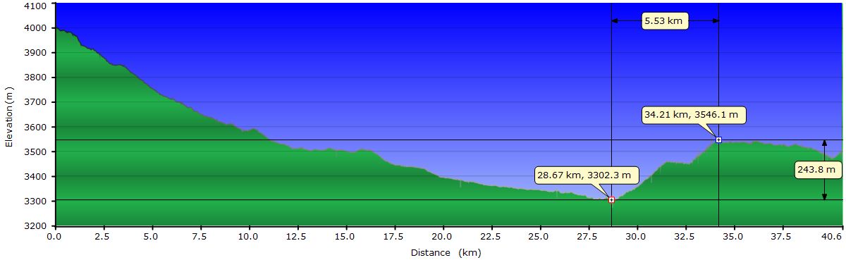
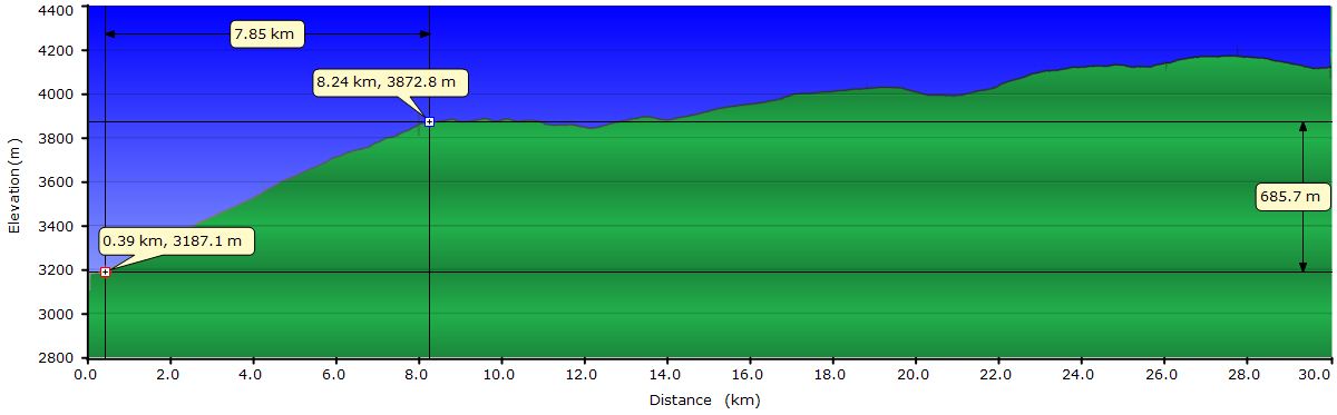
July 20, 2011: From Potosí to nowhere (Profile)
July 21, 2011: From nowhere to Cienaguilla (Profile)
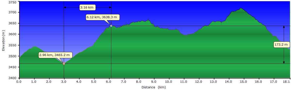
July 22, 2011: From Cienaguilla to Tinguipaya (Profile)
July 23, 2011: From Tinguipaya to Cienagoma (Profile)
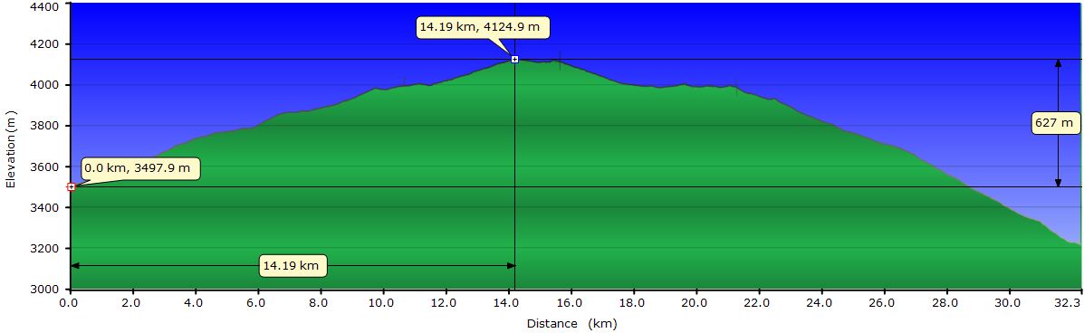
July 24, 2011: From Cienagoma to (Colque) Maragua (Profile)
July 25, 2011: Colquemaragua festival
July 26, 2011: From Colquemaragua to Chaunaca (Profile)
July 27, 2011: From Chaunaca to Quila Quila (Profile)
July 28, 2011: From Quila Quila to Sucre (Profile)
Maragua.JPG)
Maragua2Chaunaca.JPG)
Profile for the entire stage:

July 20, 2011: From Potosí to nowhere
Unlike other cities, leaving Potosi is quite easy. Traffic on Highway 1, which goes to La Paz, is very light. Even the streets leading to it are not too crowded. The only unpleasant moment is when we make the mistake of stopping behind one of the microbuses. Even with the exhaust pipe going almost up to the roof, the cloud of black smoke when they start moving is such that you are engulfed by it. On top of this, since we are at 13000 feet, you can only hold your breath for a few seconds. Inevitably you end up inhaling some of the smoke, but only once, for the lesson is quickly learned.
 During the first 7.5 miles the road goes down. At the end of the descent, the road crosses a gorge, a valley opens wide and the terrain levels out, but still goes down with a gentle slope. It seems incredible that there is so little traffic. In addition, the drivers are very bike-friendly and they completely switch to the opposite lane before passing us, leaving ample space. Arriving at Tarapaya we leave the main road and ask the locals if we are on the right road to go to Tinguipaya. The answer is no, we should follow Highway 1 till Yocolla and then take the road to Tinguipaya. We know that option exists, but the one we have planned is shorter, so we ask if we are good for Mondragón. "Yes, yes, this is the route to Mondragón."
We are surprised that the road is still paved and it continues so until Miraflores. Between the 2 villages we pass the Eye of the Inca thermal baths. When we get to Miraflores, we make sure we take the right direction to Mondragón. The pavement ends, but instead of a dirt track, we find a road paved with cobblestones that will take us to Mondragón. Arriving at this town we can see a canyon in the distance where the river we follow escapes through. At the entrance of Mondragón we find a small store and stop to buy more water. The old woman who takes care of us is super friendly and asks us where we are going. We tell her to Tinguipaya and she replies that we missed the turn off, we must go back and take a track that goes up. Good thing she was curious.
 Now the path is already dirt, but in good condition. Only a few short stretches have stones or rocks. The climb is not very steep, so we make good progress. Once we are higher up, we understand why the road climbs. We're going around the canyon, which is narrow and deep. The wind has slowly increased, generated great clouds of dust and reduced visibility in the distance, preventing us from seeing the end of the canyon.
At mile 21 we reach a pass and stop to have lunch. From here we descend gently to a junction that goes to Moropoto, a tiny village that looks abandoned. We pass the turn and continue towards Tinguipaya, our destination for today. Until now we are following the route we drew yesterday on the maps we got from the IGM (Military Geographic Institute) in Sucre and Potosi. In both offices they helped us enormously to get maps that cover this area. They warned us they are old (from the 70’s) and are not updated, but these are the only ones we know exist.
Farther ahead we find a junction that is not on the map. We would take the right fork, but is in terrible condition, covered with bushes and impassable to vehicles. However, the left one does not follow our direction. We explore on foot the left fork, up to a vantage point and definitely it’s not going where we are headed. In addition, the direction of the power line in sight confirms our decision. So we push the bikes to overcome the non cyclable section and descend to cross a dry riverbed. We push the bikes again uphill trying to avoid the thorny bushes that have grown on the road. We are sure we are going to have a flat because it is impossible to avoid them all. In some of the climbs Judit gets too far behind. In the roughest climbs we have to push again and occasionally I go back to help her to push her bike. Before a couple of miles we realize that her rear wheel is losing air. We knew it. Judit is strangely tired and her throat is sore, so she sits down as I begin to replace the tube. She doesn’t feel well and although it’s sunny, she begins to get cold, so we decide to pitch the tent right here and wait to see how she feels tomorrow. Once inside the tent, she has chills and looks for the thermometer in our first aid kit. Indeed, as she suspected, her temperature is higher than normal. She changes clothes, takes a couple of antipyretic and anti-inflammatory pills and gets into the sleeping bag. I adjust the disk brake to avoid the dragging after removing the wheel and while she rests, I walk up the road to see where it leads. We find it very strange that this road is so overgrown. Supposedly we are on the main road in the area. Perhaps they have built an alternative one easier to maintain. I climb a small hill from which I have a good view. From here I see that our road joins another track in good condition. It seems that the theory of the alternative road could be confirmed. I go back to the tent and prepare a tea for Judit who is unusually tired. The air is very dry and despite the 2 two-liter bottles we bought in Mondragón, we have only some left, so we decide to have something that doesn’t require water for dinner. Our dinners usually consist of soup or pasta, but today we are having cereals. Gradually Judit is feeling better, but the fever doesn’t go down.
Although we are at 11500 feet, it’s not too cold. From inside the tent we notice the moon light shining brightly outside. Of course, this doesn’t prevent us from falling asleep instantly. Tomorrow we will decide how to proceed.
July 21, 2011: From nowhere to Cienaguilla
We start to stretch when the sun begins to heat the tent. Judit is feeling better but her throat still hurts when swallowing. The decision is to proceed ahead with the initial route. Instead of the usual cereal with milk, today we eat the cookies we bought at the convent of Santa Teresa in Potosí. These are a kind of pastries a little rough to swallow but we want to conserve water until we can recharge.
We follow the road full of thorny bushes to get to the track I saw yesterday from the top and take it in the direction it seems correct to us. A couple of miles ahead we see a shepherd at the foot of the mountain and stop to ask her. We have been warned that the residents of this area are wary of strangers. They fear they may come to take away their lands or force them to move out. We see that the shepherd leans over to pick up a stone and places it in her sling. Fortunately it´s to control the herd of goats she guides. Judit, despite her tiredness offers to go down to ask her about the road. We think the shepherd will feel less fearful talking to a woman, even if she has red hair. From the track I see the two of them making gestures and pointing to where the road continues. Finally they shake hands and Judit begins to climb back up the hill to where I am. When she arrives, she says panting: "she only speaks Quechua, I have not understood a word". Great. We have been warned about that too. I look down and see that the shepherd starts to run towards us. She leans over again to pick up some stones and unrolls her sling. This time she is coming for us. But no, the herd was approaching the road and she throws a few stones to make the goats come back down. Judit, even not understanding a word, found her very friendly.
We decide to resume and go ahead. The track continues to go downhill and at the bottom we see a canyon with vertical walls, which scares us. After a curve, Isla, another tiny village, appears in sight and we stop to ask again. This time it's my turn. Of the 20 houses we only see a couple of people, busy in their courtyard. Luckily this time the old man speaks Castilian. He tells me that we are indeed in the old road to Tinguipaya, but nowadays “you can only make it on foot, it´s not feasible for motorbikes". The bridge over the Pilcomayo River partially collapsed years ago and you can only cross it on foot, clutching to the structure that remains standing. "The bridge is 70 feet from the water. If you fall, bye bye. The water will take you away". In addition, across the bridge, the road is abandoned and full of thorns. It takes me 3 attempts to make him understand that we are on bicycles, not motorcycles. When he finally understands then it seems more plausible, so I draw a map in the sandy soil using a stone. He must think I'm stupid using a stone, when the finger is a much better tool and he adds some details to the map. After talking a bit more he seems to think it´s not a crazy idea to cross with the bikes so I finish the conversation and ask for water. He offers to take it from a bucket connected to a hose. The water is clear but I ask him where it comes from since they warned us that water from the Pilcomayo river is polluted with mercury and he just said that the destroyed bridge is to cross the Pilcomayo. "No, no, this is from up there, not from the river". When we shake hands and turn my back to leave, he says, "But you will suffer if you go that way. You should go back to Totora D on Highway 1 and take the other road to Tinguipaya”. Puf. The truth is that even speaking Castilian it’s difficult to communicate. In addition to speaking like Master Yoda from Star Wars, putting the verb at the end of the sentence, they say one thing and after a while the opposite. I go back to the road where Judit sat a while ago, tired of waiting. I repeat the misleading information and we decide to keep going. A few yards ahead see 2 more people. They look younger and perhaps we can communicate better with them. In addition, it will be a second opinion. The father speaks Castilian and he is more or less consistent with the old man, but with more emphasis on to turn back to Totora D. This time the map on the sand is in 3D and he describes how the road overcomes the vertical walls of the canyon. Back on the road again, this time we decide to follow locals’ advice and return to the asphalt through the road they told us, rather than face the broken bridge and thorns.
 So, despite seeing the way up across the river, we turn around and go back. Following the dirt road that should take us to Totora D, we see across the valley the track that (we think) they recommend to get to Tinguipaya, but there is no connection from here. Along the way we find a car that goes to Isla and they confirm that to get to Tinguipaya, we must go back to the paved road. When asked how much climbing we have ahead, they say, "Pure downhill, right here down the road it begins". The road, though gently, continues to go up for several miles and from above we see many tracks that are interconnected. It looks like a maze. We ration the water because we don´t trust the one from the old man´s bucket. We arrive to a new village, called something like Tuskapajio, according to the only family we see. We stop to check our direction and see if they have some bottled water. I ask them and they confirm we are on the right road. They don’t have bottled water, only one bottle of soda. I come in the courtyard and the woman comes out from the house with a bottle with a pink liquid and a glass. She wanted to invite me to a glass of strawberry soda, but I explain that we have run out of water and we still have a long way to go. I wanted to buy a bottle of water. They are from Potosi and have come to visit her father-in-law who lives in the village. This is the only bottle they brought with them. I ask her if they would sell it and after a few phrases in Quechua (I guess) to her husband, she gives it to me. I insist on paying something and she repeatedly rejects my offer. The husband goes in and comes back out with a couple loaves of bread and gives them to me. Although we have plenty of food, I cannot refuse the offer. Meanwhile, one of the girls has started to grind fresh tomatoes on a flat stone in a corner of the courtyard. To grind it, she uses another crescent-shaped stone that she balances rhythmically from side to side over the flat one. She explains she is grinding tomato and locoto, a hot pepper widely used in the area. The husband suggests that I dip a piece of the bread he has just given me to try the sauce. I can’t refuse, so here I go. It is excellent, but I'm not convinced of the hygienic conditions, so I say goodbye before I have to try again. I go back to the road and besides drinking half of the strawberry soda, we gobbled up the two loaves.
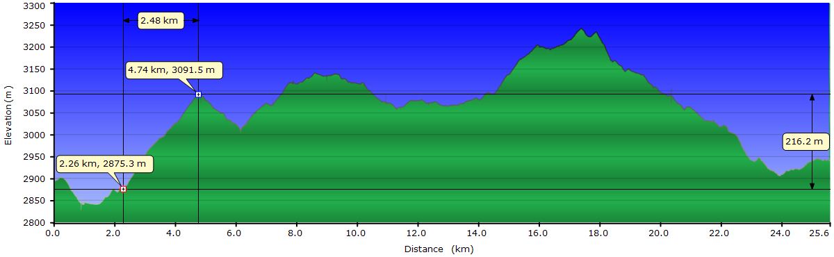
After a little more climb we get to a pass from where the track drops to Totora D. Judit is feeling exhausted and we postpone the decision to where to continue to until we reach the pavement. Once there we buy water and analyze the options. We finally decide to stick to the plan to tour the Cordillera de los Frailes. Judit is too tired to keep riding today, so we ask for accommodation in Totora D, but there is none. We get on a bus that takes us to Cienaguilla, near where the track to Tinguipaya begins. According to the driver in Cienaguilla we will find accommodation. We stop in front of the place and there is no vacancy. The other “hotel” in the village is under construction, but we managed to convince the owner to let us put the tent in an empty room on the top story and there we settle. We have dinner at the restaurant: rice soup with French fries on it and ají de carne, a kind of spicy stew with rice and andean potatoes. The kitchen is visible and I get close to see what the ají de carne is. From now on we have to reduce our cleanness requirements: here in Bolivia, at least in the villages, food is served with their hands.
July 22, 2011: From Cienaguilla to Tinguipaya

At 6:40 the owner starts yelling from the restaurant below and awakes us. We assume it´s to wake up the girls who work at the restaurant, but we start to get going. At 9:00, an hour earlier than usual, we're pedaling. By that time, the girls are preparing breakfast for the human cargo of the truck just parked at the door.
 A mile from the restaurant we leave the asphalt and start to climb relentlessly but with acceptable slopes. This will continue over the next 9 miles. On the way, we cross some villages with only a handful of houses, some of which are crumbling. In fact, along all the way, looking in any direction, you always see a house or potato fields or corrals for animals. Everywhere there are herds of donkeys, cows or llamas that seem to be abandoned. The sheep and goats are usually carefully controlled by mostly women shepherds. Although they have a dog, the method for leading the herd is based on throwing stones to frighten the animals and make them jog to where the shepherd wants. It seems incredible that this inhospitable place is so populated. The land is barren, the rivers are dry, the slopes are precipitous and the terrain is the most rugged we have seen. Passing through the villages there is almost always someone to confirm our direction, which we recheck as often as we can because the road has many detours and no signs. People always ask us where we are going and where we come from. With these brief conversations we learn that in Tinguipaya a soccer tournament among the surrounding communities is being held.
After passing the main mountain pass of today we find a half-frozen lake. It's fun to see how a group of ducks tries hard to get around. At times they swim, sometimes they walk on the ice and occasionally they break it and sink. The best part is to see them land on the ice, sliding a long way to end up stopping successfully or falling in the water.
 A little later we descend to 13000 feet where the track runs through a plain full of llamas. On the slopes across the plain there are lots of stone houses and corrals, but everything seems abandoned. At the end of the plain there is an artificial lake from where piped water is taken for the Tinguipaya Valley below. Just passed the dam, the descent that will take us into town begins. The downhill is a series of back to back zigzags. Within 6.25 miles we lose 2600 feet. This road has to snake down a single hillside, because the adjacent ones have sharp vertical rocks. A downhill is always a blast, but this is less so. Across the river that passes by Tinguipaya there is an uphill equal to the one we are going down right now, waiting for us for tomorrow. Anyway, we enjoy the views from the top, the color changes of the road we ride on and the sunny day we have.
 At Tinguipaya we almost get a free shower from the roof of a house when somebody throws a bucket of water to the street. Upon entering the main plaza, we ask for lodging and a couple of people tell us that everything is full due to the soccer tournament. We go to the town hall and even the municipal tambo that hosts a number of teams is full. Anyway, they let us set up the tent in its kitchen. The room is so small that we cannot close the door when the tent is up. Obviously, we are the object of attention and the curious poke their heads to watch us. Tomorrow we expect a long climb so we go to sleep soon.
July 23, 2011: From Tinguipaya to Cienagoma
 Before we set off, we have to go to 6 different stores to buy a can of tuna, some bread and four bottles of water. Loaded with 2 gallons of water we face the climb, which will take us on the way to Maragua. The first hill is brutal and we have to stop and push the bikes. For some unknown reason, on all the curves there is a buildup of sand hiding some rocks and making difficult to keep the balance. During the first 5 mi, the slope is a ridiculous 9%. The "mobilities" that transport people and goods crawl up with the engine in first gear, raising a cloud of dust and fumes that surrounds us. Today we see across the valley yesterday’s downhill and have a better view of the other valleys and ridges of the Cordillera de los Frailes. Despite the physical effort, the scenery is worth it.
 Around mile 5, the slope flattens to acceptable levels, but we continue to go up during the next 12.5 mi, almost to 13800 feet. Along the way we cross all kinds of cars, trucks and buses, all crowded. All of them say hi and some even stop to chat. "Where are you going?" To Maragua, we answer. "Ah! It’s still far away”. The hillsides of the steep valleys are dotted with clusters of houses surrounded by crop fields. It seems incredible that they can grow anything on these slopes. If a farmer´s job is already a hard one, imagine on slopes of 30 and 40 degrees and at 13000 feet.
Behind each curve there is another one for miles and miles uphill. Around mile 17 and after climbing 3600 feet, although it´s only 4:00PM, we're thinking about camping and continue to Maragua tomorrow. We are in one of the tiny villages that we have been passing by and Judit asks a shepherd if we can camp somewhere. She understands Castilian but only speaks Quechua, so there is no exchange of information. At that very moment, a young guy shows up walking in the same direction we are going. We ask him and he tells us that just around the curve we see on the horizon is Cienagoma, a larger village where we will find lodging. He is heading towards it and resumes his way briskly while we get on the bikes. After a few curves we pass him and he again states this is the last curve. After this, it's all downhill to Cienagoma. When we are still a few yards from him he asks if we can take him. At this point the slope is gentle and it seems that the distance is short, so I tell him to seat on my saddle and I’ll pedal standing. We don’t know yet, but there are at least 1 more mile up and 1.5 down from Cienagoma! I have to stop a couple of times to rest while going up. During the descent he is the one asking me to stop. With the bumps he is slipping forward and I guess the tip of the saddle is hurting his sensitive parts. When we finally get to Cienagoma Judit thinks he is limping as he heads toward the houses. In fact, he puts his hands in his pockets to clearly relocate things.

The village has less than 20 houses but the school is brand new and has a sports court. We ask if we can sleep in the school building but it´s closed and the principal doesn’t return until Sunday morning. However, we are allowed to put up the tent on the sports court. By now we have a group of curious children around us who will follow us everywhere. We go to the sports court and see that some of the classroom windows are broken. We sneak through one of them and settle on an empty class. We take advantage of the last moments of sun to clean the chain, covered with dust for the last 4 days, under the close supervision of the kids. When we put up the tent they watch us with their eyes wide open. One of them attempts to enter the classroom and we have to stop him. Of course, when we get into the tent, they do all kinds of mischiefs like knocking on doors and windows and run away immediately while laughing. We don’t care too much. We know that when the sun goes down at 13500 feet is too cold outside to go around doing such things. When we brush our teeth before going to bed, we have an opportunity to enjoy the incredibly starry sky. The Milky Way is amazing here.
July 24, 2011: From Cienagoma to (Colque) Maragua
 As expected, shortly after the first crowing of cocks, the kids are peeping through the windows from outside the classroom where we spent the night. It's 7:30 AM and it’s too warm inside the sleeping bag to wake up. As the kids don’t see activity outside the tent, their impatience increases and begin to knock on the windows and door. We keep ignoring them but their next strategy is to throw small stones at the tent through a broken window. As they will not stop until we pop out of the tent, we decide to stretch and start the routine of a new day. When we open the zippers, we see new faces on the windows. Today there are girls as well as one of the boys we met yesterday. The best expression on their faces is when we pick up the tent: mouth and eyes wide open. And it’s totally understandable, they see an igloo where we put a bunch of bags and 2 people and 5 minutes later they see the igloo rolled and tucked inside one of those bags. When preparing the panniers and taking them out the window we are not interesting anymore and the girls move to play to the soccer court. The game consists of kicking a flat stone as they jump on one leg in order to place the stone in a set of boxes painted with chalk on the floor. Not very different from a girls’ game of our generation. The equipment itself is a bit different. These girls wear sandals, probably made of an old tire. We say goodbye to them and begin our day crossing the village.
 We resume the climb we didn’t finish yesterday and after about 4 mi we reach the first pass of the day, at 14300 feet. As it has become normal, there are clusters of houses and crop fields everywhere and there is always a trail that communicates them with the main road we follow. Up the hill a herd of llamas graze peacefully. When we get close they raise their head to see what’s going on, showing the bright colors wool tassels hanging from their pointing ears. On the other side of the pass, as it’s also becoming usual, we see the climb ahead to go back up from the valley bottom. Down in the valley there is another tiny village where we want to confirm our direction before starting the ascent. It seems that there are only women and no one speaks Castilian, but naming the next villages in our route, they understand us and point up to the pass. The village is surrounded by herds of llamas and donkeys. While I ask for directions a baby llama comes close to check what are those metal things in which we ride. It approaches to smell Judit’s panniers but doesn’t seem to find anything interesting and goes away hopping. When I come back from asking the women, it approaches me but I guess 4 days pedaling without showering is too much for its sensitive nose. This time it trots away.
The climb of the second pass is in general acceptable, but Judit still has that sore throat and if she stops taking the antipyretic pills, the fever appears again, so we take it easy. After overcoming it, we descend about 650 feet and start the third and final pass of the day. To get to the top we just have to climb 150 feet, but it seems like 1500. At this elevation, the effort is multiplied. Almost reaching the summit, we catch up with a peasant leading his 4 donkeys loaded with sacks. We talk to him a few minutes and learn that he is heading, like us, to Maragua to sell their goods. The donkeys are loaded with chuña potatoes, one of the types of Andean potatoes grown in the area. They have the peculiarity that once harvested, they are dried in the sun and frozen at night for a few days. They also carry dried meat. It turns out that tomorrow there is a celebration in Maragua, so there will be a ton of people and that always means business. For him, the business can start right now, and he tries to sell everything to us, from potatoes and meat to his own hat.

The downhill to Maragua is continuous, almost 1600 feet in 5.6 mi. It´s only interrupted by several dogs that come to us barking fiercely, but they already know what a stone is. When we stop and lean over to pick up a couple of stones, they stop barking. If we threaten them to throw the stones, they turn around and disappear. Some are stubborn and we have to actually throw the stones to scare them away. Halfway down we stop to have lunch and enjoy the views of the valley we will follow towards Potolo. On the other side of the valley we can see the climb towards Ocurí, but luckily it’s not for us.
Once in Maragua we find a shop run by a couple of very nice and lively elderly to replenish water. They tell us that tomorrow starts the village festivity, a bunch of people will come in groups wearing traditional costumes, dancing to the sound of the charango, etc., etc. They finally convince us to stay. At first we were reluctant to stay because these parties include fights among participants from rival villages with some degree of violence that in some cases even ends up with the death of one of the participants. As they say, if there is a good fight, it’s a good party... Alcohol is drunk in quantity, which always creates conflicts. But we are told the dances are in the morning and men do not start drinking until the evening, so our plan is to stay and leave around noon. The next step is to find accommodation. The store owners tell us that next to the church there is a small room where we could spend the night, but one have to ask permission to the mayor. Just then the mayor passes by riding his motorcycle. The old man gets up quickly calling him and gets his attention. No problem, we can stay there. Now we have to find Atanasio, the person who has the keys. The plan for this is to sit back again in the doorway of the store, just where we were before the mayor showed up and wait for Atanasio to pass by. During the next two hours we talk about the party, the Copa America tournament, tourists who pass through town... We finally figure out the mystery between the two Maraguas in the area. We are now in Colque-Maragua (Colque means silver in Quechua). The
Maragua related to the crater we will visit in a few days is called Trigo-Maragua, due to the wheat fields.
The main street is lined up with stalls selling all sorts of products: food, charangos and decorations for tomorrow’s costumes. At all times people are going back and forth, so we are entertained. Although one might think these seniors just let time pass, the reality is that they don’t miss any detail of what is happening: the mobility from Sucre or Potosi, who passes by and where they go, the pair of gringo backpackers who just arrived, and so on. Finally Atanasio shows up. The old man calls him but he is too busy to talk about it now and will come back later.
 It’s beginning to get chilly and the four of us move across the street to warm up in the sun on the opposite sidewalk. They invite us to eat a tangerine and we continue chatting while passersby can’t refrain to give us a look. It would seem that we have come to visit our grandparents but the cyclist gear we are wearing makes it clear we are tourists. From the shadow of her hat, the bright eyes of the wife continue to control everything. When someone sticks the head in their business, the husband goes to assist the client. If he is not with us at that time, then she goes, limping badly due of some type of accident. After taking care of someone, she stays in the doorway of the store and a young man sits there and starts a conversation with her. We're now too hot in the sun, so we move again back to the other sidewalk and sit on the curb beside them. Gustavo turns out to be a diocesan about to be ordained and has come to celebrate Mass for the festivity. After a careful but thorough review of our Christian record, he offers us a room at the back of the church, where he is also sleeping tonight. As Atanasio doesn’t show up and the sun is setting, we accept the offer quickly. Besides, Judit needs to rest, a village of 200 inhabitants has not enough emotions to keep gossiping on the street after 3 hours.
We settle in the room next to Gustavo’s and after a snack, Judit lies on the only bed in the room. I, from the sleeping mat on the floor, use the time to write up today’s experiences as the band of the village incessantly repeats the same tune in the plaza. The party has begun. Occasionally they throw fireworks and firecrackers, but even all that rumble cannot wake Judit up.
July 25, 2011: Colquemaragua festival

Today is the big day for the farmers around Maragua. They left their villages and communities very early in the morning towards Maragua. Yesterday they told us that after 9 AM the first groups of dancers start arriving, so at that time we are in the plaza waiting. The main street is quiet. Vendors are still putting together their stalls, store owners take out boxes and tables to the sidewalk to show their products better. At 10 everything is more or less the same. At 11 no group has showed up yet. In theory, at this time begins the religious celebration in the church. As we need to coordinate with Gustavo for the single key to the residence of the parish, we go back to talk to him. The Mass will also be delayed. The farmers should still be on their way.

 After a few minutes we can hear voices and music at the end of the main street. We look from the corner and finally the first ones arrive in Maragua. This is a group of about 20 or 25 components dressed with all the garments and all the colors you can imagine. Today is the day when men show off, tomorrow is for women. For the male costume there are two kinds of hats. The simplest is shaped like a cone with two triangular pieces to cover the ears and a hanging rope to tie them around the chin. Both the tip of the cone and the strings end in wool tassels. It’s woven in wool with geometric patterns. Most are colorful, others have just a pair of tones within the same gamut. This type of hat, in addition to be used at celebrations, is also used daily. The montera, the second type of hat, is used exclusively for the festivities. It is shaped like the metallic helmets worn by Spanish soldiers during the conquest, but made of cow leather. In addition to the cap that covers the scalp, it has 2 sharp ends, on the forehead and neck. The brim covers much of the cheeks, so that almost the entire head is covered. The leather pieces can be of the same color or different colors. Above the leather, most monteras are richly decorated with wool tassels of various colors hanging or attached to the cap golden borders. Or both. To top the spectacular montera, one or more long colored feathers come out of the upper part. Between the hat and the head, most of the dancers catch a corner of a large silk handkerchief, so that the rest of it hangs on their back. Above the handkerchief and tied to the cap, they place tufts of wool in the form of pigtails. The most complete costumes include embroidered waistcoats and woven bands tied from the belly to the lower back passing through the shoulders. At the waist, wide belts of different colors overlap to be tied back and hung like a tail almost to the feet. There are other equally colorful pieces of cloth hanging in front in the form of skirts. The arms are decorated with narrow bands, hanging bells and colored balls. The calves are adorned with a kind of socks with different patterns, various colors and bells. This would be the minimum equipment to be someone in the party. Now if you want to stand out, you must add distinctive garments and this is where the imagination, especially for the youth, overflows. Fingerless gloves, rock sunglasses, ski ear covers, screaming colored or heavy bands shirts, etc… Some have their faces painted or wear both types of hats, one on top of the other. Now you start to be someone. You just need to hang one or two charangos and a pair of Andean flutes to be the star of the party.
 The girls today are wearing far less showy dresses, but the colors of the skirts and blouses are bright. The long pigtails almost always end in some kind of embellishment to match the skirt. Some have the typical multicolored striped shawl on her back, tied at the chest, passed over the shoulder. In normal days it’s used for carrying groceries or babies, but today’s are more elaborated and just to show off.
The rhythm of the music is very repetitive and is marked by the dancers’ footsteps running synchronously. The charangos and flutes are the only instruments used. The lyrics of the songs are in Quechua and although we don’t understand a word, we almost dare to say that are always the same. The groups advance from the entrance of Maragua where they come from their communities to the plaza, occupying the entire width of the street. In front of the church they form a circle with the charangos in the center. Every few stanzas they stop turning and perform a strong footwork. Then, they turn again, this time in the opposite direction and repeat. If the space in front of the church is occupied by another group, they align in a row and wind across the plaza between the other dancers.
 As the morning passes, new groups are coming from their locations and have to occupy the adjacent streets to the plaza and the soccer court next to it. Chicha, a drink made of fermented corn begins to run through their veins. Before drinking from a cup, they pour some to the ground as an offering to the Pachamama, the Mother Earth. By 3 or 4 pm the large chicha containers begin to empty and movements are less graceful and choreography less synchronized. The changes of rotation direction begin to be a little chaotic but they all end up rotating in unison. Around 5 the level of alcohol brings out the first attempts of fights. Contestants push each other but soberer mates succeed to separate them. According to the locals, most parties end with fights. The people of Maragua say these peasants are brutes, “This is their party and you have to let them celebrate it their way”.
 Our plan was to leave before noon but since everything has been "delayed", we decide to stay another night here. Judit continues with that cold and she could use a rest day to recover faster. It's ten o'clock at night and we still hear music in the plaza. They say they dance all night, but we doubt very much that at this time one of them can keep the balance. The show has been brutal, a saturation of the senses. Best of all is that this really is a festivity for the participants and they care little about the public in Maragua and the 4 tourists (two gringos and us) that are witnessing it.
July 26, 2011: From Colquemaragua to Chaunaca
Long before 7 AM we hear the same tune that was been played all day yesterday. It turns out that yes, they have been dancing and playing all night. We poke our heads into the street and indeed, some groups are still repeating the same dance as yesterday, less vigorously and with fewer participants though. We guess some have fallen in combat and are still sleeping drunk.
 After breakfast we say bye to Gustavo and leave Colquemaragua along the river. What in our 70’s IGM map is a trekking trail, today is a dirt road where all kinds of vehicles travel, so our concerns about finding the way from Colquemaragua to Potolo vanish. The landscape has changed radically from the one to reach ColqueMaragua. The valley isn’t that deep and the river bed is wide although the flow is low. Along the way we meet people walking back to their villages, which have not stayed for today’s festival. Others are going to Colquemaragua to be present on the second day of celebration. Today we pass many herds. Judit names one of them the Ark of Noah, as it is composed of donkeys, pigs, goats, sheep and cows, besides a man and a woman.
 Gradually the vegetation becomes more abundant on the river banks. Small forests of eucalyptus stand out. Pedaling downstream is always a guarantee of fast pace. Although narrow valley means to dodge up and down rocky ledges or canyons, on average, is downhill. The valley narrows twice, once with towering vertical walls. Around mile 19 we arrive in Tomoyo where two rivers meet. We take the turnoff to the right and continue downstream. We enter a broader valley with large crop fields on both sides of the road, very different from the ones we have seen so far, hanging on the hillsides. Livestock also seems an important activity in this valley. The communities we are passing through are still tiny. Yoroka, Sorojchi, Molle Molle don’t exceed a handful of houses concentrated around the road plus another handful scattered. Near this latter community, erosion has exposed light gray and purple rock bands that stretch for miles. They almost extend to the pass we must overcome to cross the border between the departments of Potosí and Chuquisaca. From atop, a rapid descent leads to Potolo. This was a possible destination for today, but it is still early and we decide to keep going, especially because the town seems deserted.

Now we follow a different river, but still downstream. However, after a while it flows through a gorge and we have to climb up and then down to go around it. This is the last significant climb of the day. On the other side, with good views over the canyon, we are rapidly approaching Chaunaca. We cross the Ravelo river and we have only one last ramp to the village. Chaunaca's population is only about 50 people, but we find lodging with hot shower. After 7 days without showering (not because we are afraid of cold water, but because there was no shower in any of the places where we slept), it is a pleasure and reminds us how well accustomed we are to certain common things that elsewhere are a luxury.
July 27, 2011: From Chaunaca to Quila Quila
The cereals we bought yesterday in one of the two stores in Chaunaca are a fiasco for a breakfast. Yesterday we gobbled up one of the bags when we settled. For that, the popcorn-flavored chocolate was acceptable. But today, when we dip them in milk they become a lumpy mass that slips on the spoon and is difficult to swallow. Perhaps it’s the reaction with the milk powder. In the end, the best solution is to eat them without dipping. The worst thing is that we bought 3 bags...
 While we clean and lube the bikes in the sun next to the courtyard of the school, the teacher instructs the students to perform some physical exercises with military commands. Students have their eyes fixed on us and pay little attention to the Sergeant. At the command of "dismiss" the students answer "Viva Bolivia", break ranks and start sweeping the yard using bundles of straw as a broom.
We leave Chaunaca and pedal down directly to the river. There is no bridge to cross and Judit, the smart one of the couple, removes the bags and walks her bike through the huge stones arranged for this purpose. I, the macho, cross the river riding and, having miscalculated the depth of the water, get my feet wet up to the ankles. Just today I put clean socks after yesterday’s shower...

The climb across the river is only 700 feet up, but in less than 1.5 mi and we have to stop several times to rest. Judit, who is slowly recovering from her cold, now feels better and goes up ok except for some coughing. Then we go down to a revine to climb back up the hill that leads to the plateau where Trigo-Maragua, or simply Maragua is. This road is relatively new and certainly not on our IGM map. Although the track only has a couple of years, the terrain is not in good condition. Rocks, sand and gravel makes it difficult to progress faster. According to the Lonely Planet guide book, the view of the Maragua crater is one of the most amazing panoramas is Bolivia. Well, it’s good but not that spectacular. The rocks of the flat area are purple and the strata of the Serranía de Maragua to the south, forms some chained curious arches. In the center of the depression there is a small hill where the cemetery is located. We ask at the village how to get to the Talula hot springs. According to our map, there is a trail but a couple of locals do not recommend it for cycling. They advise using the new track leading to Quila Quila and then take the road to Talula. After the experience during the first 2 days of this stage, we decide to follow their advice and head to Quila Quila. To get there, means climbing the Serranía and that means more rocks and sand. On top of that, today is much warmer than any other day and the sweat runs down our faces. From the summit we can see the church of Quila Quila and we rush down the hill.
 The town seems deserted. Probably everybody is avoiding the heat inside their homes. We don´t hear anything, we don´t see anybody until we get close to the school. There, the bustle of students indicates that there is life in Quila Quila. Obviously there is no accommodation here, but a woman offers a small room in her house in exchange for a few bolivianos. The room is actually more a warehouse full of dusty junk so we look for another option. At the school, one of the teachers, Rubén, offers his classroom, which is a great solution for us. We move a table out of the way and put up the tent. Although it is early and we could visit the nearby cave paintings, we are exhausted, probably partly by the heat. We stay in the cool classroom doing nothing. Around 4 PM Rubén shows up and invites us to have dinner at his house. We gladly accept and, after dedicating some time to dust off and lube the bike chains and gears, we groom for dinner. Rubén and Mariana (also a teacher at the school) have prepared a chicken rice and ají which is very tasty. During dinner we talk mostly about Bolivia. One of the data that is most striking to us is the existence of 36 nations in the country. Bolivia declares itself as a multinational country. According to Mariana, one of the nations is made up only by 8 people, but they have they own language, culture and traditions, so they got the nation status. Another curious aspect is the organization of multi-sports tournaments between teams working in the same profession. Like the doctors soccer championship we saw in Tinguipaya, Rubén and Mariana regularly participate in teachers tournaments at regional and national levels. We didn´t know that Simón José Antonio de la Santísima Trinidad Bolívar y Palacios Ponte y Blanco, better known as Simón Bolívar, actively participated in the emancipation of a total of 6 countries in South America: Ecuador, Colombia, Perú, Panamá, Bolivia and Venezuela, his own country. After a long chat, Rubén accompanies us back to the school as the teachers who live in it lock the gate at night. There is just a street light in the main street, but tomorrow they are going to install 3 more. It's already 10 PM, the cold is intense and Quila Quila is again deserted.
July 28, 2011: From Quila Quila to Sucre
 One reason, besides the fatigue, for which yesterday we didn´t complete the 19 mi left until Sucre is the 2 climbs on the way. It was a wise decision, because today´s profile continues the trend of the route. In the middle of the day we have a downhill into the Pilcomayo River of about 1300 feet which we will climb back up on the other side. They are building a bridge, but for now we have to cross through a chain of huge rocks. After yesterday´s failure, this time I won’t even try crossing riding. We take all the bags out and cross everything in several trips. The slope going up is almost 10% and has some sandy sections. On this road, trucks loaded with stones and sand from the riverbed go up and down constantly. Every time one passes us, we have to stop and use a cloth as an anti-dust and anti-fumes mask. Still, Judit´s throat gets irritated and she finishes the climb with coughing fits.
After a few miles we go back down now with Sucre in sight. We ride through a degraded suburb with rubbish everywhere. For the amount of children in uniform walking toward the city, it must be time to return to school. It couldn´t be otherwise, to get to the center of the city, we have to climb. At least there is little traffic and it’s not stressing. Finally we settle in a hotel one block from the central plaza and we take an infinite shower after 9 days in the Cordillera de los Frailes. We wanted to see the life of the peasants of the highlands and the tour has given us a good idea of the tough life they live. Severe weather, the continuous ups and downs of the terrain, water scarcity and isolation make this region an inhospitable area. Yet they still grow their potatoes and wheat as did their grandparents and probably their grandparents' grandparents. Having been spectators of their party at Maragua has been a plus we didn´t count on. Despite the hard and spartan life they have, there is no shortage of desire or strength to walk a few hours to reconnect with friends, to dance, play music and drink beer non-stop for a couple of days.